By Tarini Carr
Some billions of years ago the earth’s crust and surface features began to form and shift into a semblance of what we know as the Earth planet today. The shape of the continents would have been quite foreign to our eyes then, and indeed the climates were quite different as well, over the very long time from then till now, the moremany incidents occurred with some very interesting results.
One such routine incident, such a mind bogglingly long time ago, began to form what would later be known as South America. Upon this continent in what then would be the southern part of Peru, at some point in the great scale of prehistory, began to form lush valleys, and gorges, and between them all dry elevated plains. These plains were covered in small dark red surface stones that would be polished by the desert winds. The climate of these ‘pampas’ is now extremely dry, as it only rains once every few years, and there is little wind.
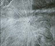
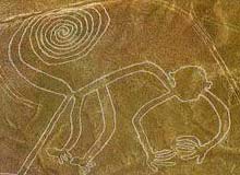
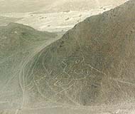
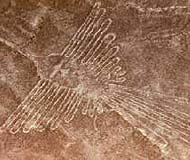 About 1500-2000 years ago the Nazca people inhabited this area. They might not be quite so well known today if it weren’t for the particular geological and climatic features of their homeland. Most people learn about the Nazca because of the famous Nazca lines etched in the desert between the Ingenio and Nazca river valleys. The desert formed an enormous drawing board for the Nazca upon which they etched huge lines, trapazoids, and animal figures by removing the dark colored surface stones and top soil to expose the lighter colored sand underneath. Spread out across several hundred sq kilometers (about 3-4x the size of Manhattan island) of the arid Peruvian desert, these drawings have been remarkably preserved. In any other climate, these drawings would have been obliterated in months, but the Nazca is one of the driest and most windless regions on earth. Much mystery surrounds these drawings, for their exact purpose and meaning remains unknown. How were they created so precisely? Some of the lines continue for kilometers on end only varying by a few degrees. For whom? And why? Even their dating is only somewhat certain, as it was approximated by the pottery shards found within the sands. It is possible of course that these lines were created before the Nazca, but it is difficult to ascertain the truth with no evidence to give us a clear and conclusive answer. As any find, or object from past civilizations is apt to do, these lines have drawn a lot of attention and speculation as to their use and reason for creation. It seems no one person can quite agree on how to understand the Nazca lines. Archaeologists and others have been trying to understand how and why these lines were formed for over 80 years. Anything from ancient foot race paths, and ceremonial walking, to alien runway’s have been suggested for the reason of the lines existence. It is necessary to explore all of these theories and to look at the recent and past research to see if one can come to any sort of conclusive picture behind the enigmatic lines in the desert.
As with all things from the past, it is nearly impossible to analze and interpret the findings with a completely objective and accurate viewpoint. Archaeologist’s, and other scientists project the ideas and values of the present upon the past. It is very difficult to escape our own cultural conditioning. This is the inherent problem within archaeology, especially, but they try to the best of their ability to understand the past with the tools they have.
How Were the Lines Made?
Fortunately one thing that most scientists can agree upon is how the lines were made. At first the enormity and preciseness of the lines seems to point to a remarkable feat of engineering. Many of the drawings must also be viewed arially to see them in their entirety, and thus it was thought that it would have required an airborn observer to aid the artists in creating the precise figures and proportions we see today. However, according to Dr. Persis B. Clarkson, an archaeologist and geoglyph expert at the University of Winnipeg “ It was not a difficult technology.all you need is the will.” It would have just taken careful and diligent attention to sight the lines. To prove this, a group of 10 Earthwatch volunteers helped an astronomer and anthropologist, Anthony Aveni, in a study of the Nazca lines. In just and hour and a half, without a printed plan, they created a straight line winding into a spiral 35 meters long and one meter wide. Splitting into groups, each one performed a different task, and the result was, according to Aveni, a figure as accurate as any Nazca drawing measured with a surveyor’s instrument. It is fairly conclusive that it was not necessary for the Nazca to have possessed great mathematical or engineering skills to create the figures or lines in the desert. It was possible simply by people working together with their eyes and hands. So there is one of the mysteries cleared up.
There will always be the naysayers, and the alien theorist’s, but it is fair to point out other possible means of these lines creation. Because of the drawings being so large, and as previously mentioned, only fully viewable from the air, it was suspected that perhaps the Nazca were capable of flight. Pottery found in the area depicted images that could have been kites, or baloons. At the end of many of the lines were found wide circular pits containing charred rocks that could have been a launching site for a hot air baloon. A big if, but one some felt was worth testing. Bill Spohrer, an American living in Peru, and Jim Woodman, a member of the International Explorers Society, recreated a baloon using materials they thought would have been available to the Nazcans. Using only the heat generated from the ‘burn pit’ to lift off, the balloon flew a total of 14 minutes, on three different tries. Although a fascinating possibility, there is no evidence that the Nazcan’s actually could have or did fly. It still remains much more likely that they lines were created only from those on the ground.
Why Were the Lines Made?
This question is not quite so easy to answer, for there are dozens of theories and no conclusive hard evidence to point to one absolutely.
Why would these ancient people make drawings so huge that they could not be appreciated from the ground, but only fully from above? Perhaps that was the point; they were intended for the eyes of the gods, as a sort of offering to them. The Nazcan’s were very religious, and much of their life revolved around the growing of crops. Their very lives depended on it, and no doubt they wanted to insure the good will of the gods. Or perhaps there was a more practical purport to the seemingly pointless lines in the desert?
Astronomical Alignments
One of the first people to study the lines was the American geologist Paul Kosok. He 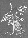 proposed an astronomical meaning to the lines, after he observed the sun setting exactly over the end of of the long single lines, on the winter solstice. The straight lines from “The largest astronomy book in the world’ as he proposed it, were intended to point astronomical events on the horizon. Keeping track of the position of the sun, moon, and other staars would have enabled the Nazca to predict when to plant and harvest their crops, as well as know when the rivers would have more water in them. By drawing upon the social developments he thought had taken place in that era, Kosok attributed the creation of the lines to a ‘power hungry-astronomer priest’ who used his knowledge and the lines as a form of rigid social control.
Marie Reiche continued the study after his death, and devoted over half her life to the measuring and mapping of the lines. She attributed a less practical application to the Nazca; they were intended as a sort of mental excersize to show off the Nazcan’s capability with geometry. Her extensive study, however, did not examine all the lines, and she came up with three different lenghts of measurement, 32.6m, 26.7, and 32.5 meters. Although possible that there is some correlation, it is probably unlikely that 3 such unrelated numbers have any real significance. Unlike the Egyptian Pyramids or Hindu temples, where their ‘sacred geometry’ repeats many auspicious numbers, such as pi, or 108.
The astronomical alignment hypothesis was basically disproved in 1968 by the astronomer Gerald Hawkins.He plotted the lines and analzyed them by computer to see if they corresponded to any constellations. Hawkins had studied Stonehenge years before and had developed a technique that enabled him to find an atronomical key to the site. Using this same technique, Hawkins found that the Nazca lines he studied were random, and did not correspond to any celestial bodies.
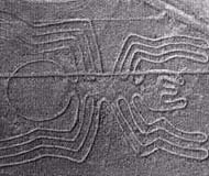
A point to note, for either of these view points, is that the scientists did not take into consideration which constellations where visable in South America, and whether they were different from those in the Northern Hemisphere. Also, little study has been done to discover which astronomical dates were important to the Nazcan’s to see if any of the events can be observed to correspond in some fashion to the lines. Without knowing what these people thought and held to be important, it is difficult to say that the monkey, or the spider, or any of the lines aligned astronomically with a particular star or group of stars. Especially as some formations are viewable only in one hemisphere and not the other.
The Cheque System
Another explanation posited for the lines is that they were a precursor to the Inca ceque system. The Inca had a tradition of imbuing power to features in the landscape. About 250 kilometers east of Nazca, is the Inca capital of Cuzco. It has four roadways, called suyus that lead out from the most remote areas of the kingdom. Spanish chroniclers documented that each of these roadways lay within 41 imaginary straight lines, or ceques, which all radiated outward from Coricancha, the temple in Cuzco which was considered the center of the Inca universe. Sacred places, called huacas, lay out on each of these ceques. Many of the ceques had the last huaca marking the subterrenean water sources of Cuzco’s irrigation system.
There were many functions to the ceque system; it provided an agricultural calender with each huaca representing a day in the agricultural year. Anthony Aveni noted “ the third huaca in the 13th ceque of the southwest quadrant consisted of a large hill with two markers. When the sun reached them, it was time to sow”. It was a very intelligent system, but that was not its only purpose. Like with many ancient people there were practical as well as spiritual purposes to their actions. The ceques were used as routes of pilgrimage, and also served a social purpose. Different classes of people gathered to worship and care for their particular huacas.
The Nazca lines, when compared to the Cuzco ceque system by Aveni and his team, were found to have a similarity to the ceques in that they tended to radiate outwards, like the spokes of wheel from landscape centers such as hills. They hypothesized that perhaps the Nazca lines were a precursor to the ceque system of the Inca. They did further research by measuring and mapping 800 of the straight lines. Remarkably, noted Aveni, each of the Nazca line ‘centers’ “bore an uncanny likeness to one another. Each one consisted of a natural hill or low mound topped by a rock cairn that may have served as an identifying marker. “. His team also discovered that the trapezoid’s axes were oriented along the underground water sources. All of these discoveries would point to one certainty: that the lines were in some important way connected to water sources. The Nazca only predate the Inca by 2,000-500 years depending on the region, so it seems very possible that the Inca may have carried on certain traditions from their ancestors.
Drawing for the Divine
What is so curious aboout the Nazca lines is why would the people have bothered to make the figures so large as to be unappreciable except from above? This naturally suggests that perhaps the figures weren’t meant for human earthbound eyes, but for the gods. The Nazca were so dependent on nature and her cooperation for their existence, they surely wished to keep the gods happy and thus perhaps the lines were merely an enormous offering to their divinities. The Nazca were an agricultural society and knew how to irrigate, plant, harvest, distribute, collect etc. However the one thing they could not control was the weather. The climate was stable for years, decades or even centuries on end, but then suddenly they would be struck with an extended drought or volcanic eruptions, earthquakes, fires, or some other natural catastrophy. Was the Nazca plain a place of pilgrimage and worship? It could have been, it is not fully certain, but it is as plausible as many of the other theories. Because the figures seem to be best appreciated from above they could have been offerings or appeasements to the gods to help them with fertility, crops, and a good source of water.
Alien Encounters and the South American Olympics
The most notorious theory of how the Nazca lines were formed, we owe to Erich Von Daniken, who first proposed that these lines and figures were ancient landing sites for aliens. He proposed that aliens landed in the Nazca desert way back when humans were supposed to be evolving from primative beings. The many lines in the desert were gouged by the landing spacecrafts of the beings from outerspace. It is probably not necessary to linger on his theories, as it falls into the same category as those that like to propound any ancient wonder such as the pyramids of Egypt as being the work of beings from other planets or universes. Even allowing the possibility that aliens may exist, the desert sand is far to soft to be a good landing spot for an arial vehicle, and does not explain how or why the animal drawings were created.
 Some have also proposed that the lines and spirals were used as running race paths. G. Von Bruenig suggested in 1980 that the lines were used for running races, after he examined the lines and determined that they were partially shaped by continous running. His imaginative hypothesis detailed a series of local races, which led up to national competitions, and even included team outfits that were supposedly depicted on Nazca pottery.
In 1978 William Isbell theorized a similarity between the building of pyramids in Peru around the same time as the lines, in that they could be a "social mechanism for investing unpredictable surpluses in ceremonial activities" in order to regulate population. The problem with this theory is that it was proved the lines could have been created quite easily, and in a short amount of time without a huge labor force. It wouldn’t have been a very effective form of population control.
All of these theories are imaginative, have very little evidence to their favor, and are overwhelmingly filled with large gaps. They are however, worth a notice, because in some ways their guess is as good as any. It is not truly known how or why the lines were created, and most likely we will never know, unless something such as a literature is discovered which can say for certain what their purpose was.
Sacred Paths
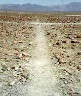
Johan Reinhard, an archaeologist known for his research on Incan ice mummies, postulated that the lines were sacred pathways to a place from which the people worshiped the mountains as the source of water, and invoked the mountain gods. Many of the lines seem to be made for walking upon, being the width of a footpath, and made of one single continous line. The animal figures, he proposed, were the manifestations of the mountain gods, who were believed to take the form of different animals and to have controlled certain animals. The Andean people still worship the gods of the mountains today. The figures were made so large in order that the mountain gods, who presumably existed above, might view them.
This seems to be a logical explanation for the animal figures, as the Nasca people were religious, and believed the gods must be pleased in order to insure good crops and reliable sources of water.
The Nazca Lines Project
The Nazca’s most important resource was water and the seasonal and long term variation’s had a direct impact upon them. Below the surface of the pampa lie subterranean aqueducts and wells. The lines placement, as seen in various studies, seems to reflect the location of these underground channels. One of the most recent studies being done upon the Nasca lines are aiming to prove that there is a direct correlation between underground water sources and the lines on the surface.
Conducted by Don Proulx and David Johson, who have been collaborating since 1996, this study endeavored to show the correlation between geoglyphs and the subsurface water flow, as well as to structural geology and hydrology. Johnson mapped the location of all the puquios and high yield wells in the Aja area of the Nazca Valley, and found everywhere there were faults, puquios, and wells, the sources of fresh water were clearly marked by geoglyphs. Further they discovered the various lines, and shapes appeared to have particular purposes. For example:
“Trapezoids were found to lie directly over the track of faults and the width of the trapezoids defined the width of the fault zone capable of transmitting ground water as concentrated flow. Triangles, or what Johnson refers to as pointers, pointed to areas where the faults crossed the ridges or hilltops. If one follows a pointer to the ridge line, evidence for the fault can usually be found in the bedrock exposures. In contrast, a zig-zag pattern located along the boundary of a geoglyph system indicated there was no water. The last correlation that he noted was that there were always archaeological sites affiliated with the geoglyphs, geologic faults, puquios and wells.” (Nasca_Lines_Project )
Johnson’s observations led them to postulate a new hypothesis to explain the purpose of the Nasca lines: that the geoglyphs were used to mark subterenean water sources, and geological faults that could tell the Nazca people where they could reliably find fresh water. As of 1999 ,a group of geologist’s and archaeologist’s supported by funding from the National Geographic Society, began to scientifically test Johnson’s new hypothesis. The goal of the group was to prove by scientific evidence that:
1. Faults intersect the valleys and often conduct aquifers (subterranean concentrated hydraulic flows),
2. Aquifers supply water to the puquios via fault systems and
3. Geoglyphs map the course of the aquifers.
The research is ongoing, but the results have been overwhelmingly positive.(For more information visit: ). This study has been the most scientific so far, but it does not account for the animal figures in the desert. Unfortunately,it seems no one theory can explain the presence of all the different lines. It is still necessary to find a more holistic hypothesis. I believe the lines probably had a religious and magical purpose as well as a practical one.
Conclusion
Whether made by the landing gears of alien spacecrafts, a homage to the gods, a sacred pathway meant for worship, or more simply a means to mark the sources of precious water to for the Nazca, the lines, figures, and animals that are etched upon the barren Peruvian plain, continue to inspire us to inquire about the past, to wonder at what was accomplished before the advent of modern technology and living, and remind us that there are forces we will never be able to understand within this universe. Life would be a lot less interesting if there were no mysteries to unravel.